
The Barbarians Are At The Gates!!!
Indeed, they live next door.
This noxious red state/blue state bullshit is poisoning the country. The press and punditry, in search of a quick and easy way to nutshell our convictions, sell papers, grab eyeballs, and dumb down reality to a level their fumbling little minds can handle have made this idea into received truth: Liberals live in Blue States, conservatives live in Red States, and never the twain shall meet. In fact, when the twain do meet, it's usually some cardigan-wearing Yuppie spilling his white wine and running right out of his boat shoes as he flees in terror from a band of unshaven, camo'd Good Ol' Boys shootin' at him with squirrel guns out of the back of a giant pickup truck.
Moreover, as anyone can clearly see, the Republicans are by far the majority party, as clearly demonstrated by a glance at the Big Electoral Map of Unquestioned Assumptions Presented As Pure-D Truth And Don't You Forget It.
Right?
Let's go to the maps!
Here's a by-county winner-take-all look at the nation on Tuesday. Pretty clear, huh? The US of A is Bush Country!
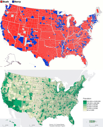
For those of us who live in blue states, this map is telling us to feel like we're being backed into a corner! The entire country hates gays and loves freedom, which we hate.
But what's that directly below the Red-Blue map? That is a map of population density in the USA. In-teresting. Bush country is largely devoid of populace, though parts are teeming with cattle. Is it possible that perhaps the Red-Blue split is nothing more than the old urban-rural thing dressed up in spiffy new colorful clothes? No! No way! That would render it almost meaningless!
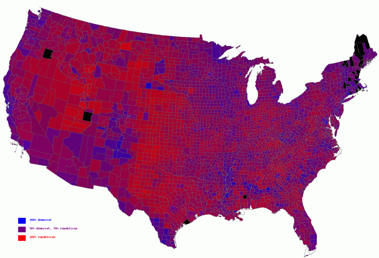
Finally, here's a map with Tuesday's by-county voting results, shaded red-to-blue depending on which candidate carried the county, and by how much. 100% BusHitler = Red. 100% that Liberal Fakey Fake Flip Flopping Frenchy = Blue. A 51-49 victory lands right in the middle between blue and red.
Well shit. What's right in the middle between blue and red??
The United States of America!
(special thanks to Crooked Timber for letting me steal the maps they found.)
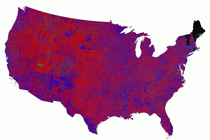
[wik] Finally... here's the same view of the country from the 2000 election, missing parts of New England thanks to data porting issues and with one county in the west partially green (implying a strong showing in the area for Kodos).
[alsø wik] Why, oh why, do I hate our freedom?
 on
| § 6
on
| § 6

§ 6 Comments
[ You're too late, comments are closed ]
I posted on this here.
I posted on this [url=http://hnn.us/blogs/entries/8344.html]here[/url].
A three and a half million
A three and a half million edge in the popular vote, and expanding majorities in both houses of congress imply that they are the majority party.
The peculiarities of the electoral college system invtes the weakminded to imagine that all Bush supporters live in rosy hued sub federal entities, and that all the dirty hippies live in LA and New York and Boston. Only a couple states had a large separation between the vote counts for the two candidates, and they were small population states like Montana and Alaska.
Where people live in a bubble - like, say LA or Manhattan, yes tehere is a huge cultural divide between them, and someone living in rural big saky country. Most fo the rest of us live in the real world. My own family runs from ultra liberal tree hugging aunt Susie, through plain vanilla liberal mom, to blue dog democrats, center right and apolitical cousins, to movement conservative me, erally conservative Mrs. Buckethead, seriously conservative father of buckethead, and religious right Aunt Diane. And that's just talking descendants of one set of grandparents.
Hmm .... Blue States .... New
Hmm .... Blue States .... New York, Penn, DC, Mass .... have they something in common? ... I must have been fantasizing in my bubble ... obviously, they are all safe from terror!
The "purple-ized" (
The "purple-ized" ("purplified"?) map tells a story that none of the others do, and it's the one that matters.
The first map, hard red/blue, is, as I think you're saying, only good for selling imagined division and strife.
Which begs the question: How many acres does it take to get an electoral college vote? Because if the number's too low, we'll seriously disenfranchise Ted Turner and whichever creditor owns Bernie Ebbers' former landholdings.
Bucket-- I agree (natch) that
Bucket-- I agree (natch) that the GOP are the majority party. But, I specifically used the modifier "by far" to reenforce the fallacy the first map implies-- that all Democrats have been pushed into coastal enclaves or small reservations in the midwest.
Nobody can deny that the Republican party came out on top this time, but as your own examples clearly exemplify, the true story is far, far more complicated.
Patton: that's a great
Patton: that's a great question! Personally, I'm okay with letting the problem get worse. Disenfranchising Ted Turner can only turn out well for everyone.